MapPlanner
0.717mi
Distance
6m
Duration
8:22/mi
Pace
Easy
Level

COURSES JEUNES Corrida Saint Georges

Route details

7.17mph
Speed
69 kcal
Calories burned
Loop trail
Route type
463ft
Min altitude
515ft
Max altitude

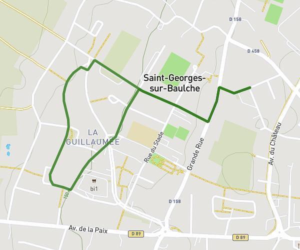
This running route covers 0.717mi starting from Saint-Georges-sur-Baulche, Yonne. The run is a loop trail and returns to the trailhead. This run is rated as easy, expect about 6m to complete it. The route has an elevation gain of 52ft and an elevation loss of 52ft.

Description of the route by the creator

YOUTH RACES: 1 LAP FOR 2012 TO 2016 RUNNING (ROAD) YOUTH RACES: 2 LAPS FOR 2010 TO 2011 RUNNING (ROAD) YOUTH RACES: 4 LAPS FOR 2008-2009 RUNNING (ROAD) start - 18:15

(Description automatically translated)

Route profile

52ft
Elevation gain
52ft
Elevation loss
463ft
Min altitude
515ft
Max altitude

How to get there

Trailhead: Rue Du Stade, 89000 Saint-Georges-sur-Baulche

GPS coordinates of the trailhead: 47.80325, 3.53053 / 47°48'11'' N, 3°31'49'' E

Caution: May Cross Private Property

This route may pass through or near private property. Always respect posted signs, obtain permission where required, and follow local trespassing laws. MapPlanner does not guarantee public access along any route.

Safety Notice

Trail and road conditions may change without notice due to weather, construction, or other factors. Always verify current conditions before heading out. You are responsible for your own safety — follow local signage, obey traffic laws, and use your best judgment on the trail.