MapPlanner
4.115mi
Distance
35m
Duration
8:30/mi
Pace
Easy
Level

Vieux Port

Route details

7.05mph
Speed
400 kcal
Calories burned
Loop trail
Route type
20ft
Min altitude
59ft
Max altitude

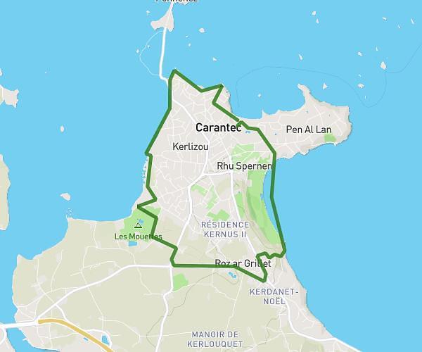
This running route covers 4.115mi starting from Roscoff, Finistère. The run is a loop trail and returns to the trailhead. This run is rated as easy, expect about 35m to complete it. The route has an elevation gain of 46ft and an elevation loss of 43ft.

Description of the route by the creator

Kersulguen Bambooloc Old port Station Gulf Stream Kersulguen

(Description automatically translated)

Route profile

46ft
Elevation gain
43ft
Elevation loss
20ft
Min altitude
59ft
Max altitude

How to get there

Trailhead: 185 Rue De Roch Klehure, 29680 Roscoff, France

GPS coordinates of the trailhead: 48.70981, -3.99709 / 48°42'35'' N, 3°59'49'' W

Caution: May Cross Private Property

This route may pass through or near private property. Always respect posted signs, obtain permission where required, and follow local trespassing laws. MapPlanner does not guarantee public access along any route.

Safety Notice

Trail and road conditions may change without notice due to weather, construction, or other factors. Always verify current conditions before heading out. You are responsible for your own safety — follow local signage, obey traffic laws, and use your best judgment on the trail.