MapPlanner
1.271mi
Distance
14m
Duration
11:01/mi
Pace
Easy
Level

EEST11 2K

Route details

5.45mph
Speed
160 kcal
Calories burned
Loop trail
Route type
49ft
Min altitude
72ft
Max altitude

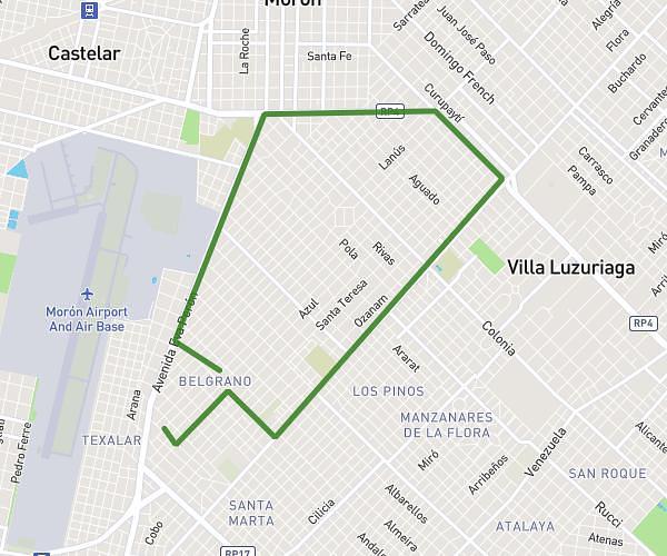
This running route covers 1.271mi starting from Ciudad Evita, Buenos Aires Province. The run is a loop trail and returns to the trailhead. This run is rated as easy, expect about 14m to complete it. The route has an elevation gain of 39ft and an elevation loss of 46ft.

Description of the route by the creator

DEPARTURE: EEST No. 11 Sports Field Chile - La Pirincha - El Ruiseñor - Reinalda B. de Rodríguez - El Güira - El Ruiseñor - El Chacurú - Chile - FINISH: EEST No. 11 Sports Field

(Description automatically translated)

Route profile

39ft
Elevation gain
46ft
Elevation loss
49ft
Min altitude
72ft
Max altitude

How to get there

Trailhead: Chile, Ciudad Evita, Buenos Aires Province, B1778, Argentina

GPS coordinates of the trailhead: -34.726325, -58.528759 / 34°43'34'' S, 58°31'43'' W

Caution: May Cross Private Property

This route may pass through or near private property. Always respect posted signs, obtain permission where required, and follow local trespassing laws. MapPlanner does not guarantee public access along any route.

Safety Notice

Trail and road conditions may change without notice due to weather, construction, or other factors. Always verify current conditions before heading out. You are responsible for your own safety — follow local signage, obey traffic laws, and use your best judgment on the trail.