MapPlanner
6.441mi
Distance
39m6s
Duration
9.89mph
Speed
+236ft
Elevation gain
-236ft
Elevation loss
Easy
Level

Aktive Mittagspause

Route details

345 kcal
Calories burned
1.4%
Avg grade
Loop trail
Route type
62ft
Min altitude
112ft
Max altitude

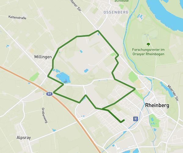
This cycling route covers 6.441mi starting from Rheinberg, North Rhine-Westphalia. The ride is a loop trail and returns to the trailhead. This route is rated as easy, plan for about 39m6s to complete it. The route has an elevation gain of 236ft and an elevation loss of 236ft.

Route profile

236ft
Elevation gain
236ft
Elevation loss
62ft
Min altitude
112ft
Max altitude

How to get there

Trailhead: Kewerstraße 41, 47495 Rheinberg, Germany

GPS coordinates of the trailhead: 51.541959, 6.587163 / 51°32'31'' N, 6°35'13'' E

Caution: May Cross Private Property

This route may pass through or near private property. Always respect posted signs, obtain permission where required, and follow local trespassing laws. MapPlanner does not guarantee public access along any route.

Safety Notice

Trail and road conditions may change without notice due to weather, construction, or other factors. Always verify current conditions before heading out. You are responsible for your own safety — follow local signage, obey traffic laws, and use your best judgment on the trail.