MapPlanner
5.219mi
Distance
45m
Duration
6.96mph
Speed
+394ft
Elevation gain
-394ft
Elevation loss
Easy
Level

St Eloy

Route details

401 kcal
Calories burned
2.9%
Avg grade
Loop trail
Route type
489ft
Min altitude
636ft
Max altitude

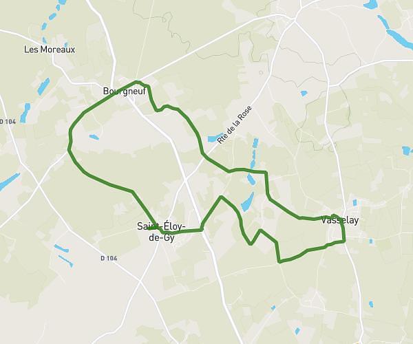
This cycling route covers 5.219mi starting from Saint-Éloy-de-Gy, Cher. The ride is a loop trail and returns to the trailhead. This route is rated as easy, plan for about 45m to complete it. The route has an elevation gain of 394ft and an elevation loss of 394ft.

Route profile

394ft
Elevation gain
394ft
Elevation loss
489ft
Min altitude
636ft
Max altitude

How to get there

Trailhead: 18 Rue De La Rongere, 18110 Saint-Éloy-de-Gy, France

GPS coordinates of the trailhead: 47.156113, 2.338843 / 47°9'22'' N, 2°20'19'' E

Caution: May Cross Private Property

This route may pass through or near private property. Always respect posted signs, obtain permission where required, and follow local trespassing laws. MapPlanner does not guarantee public access along any route.

Safety Notice

Trail and road conditions may change without notice due to weather, construction, or other factors. Always verify current conditions before heading out. You are responsible for your own safety — follow local signage, obey traffic laws, and use your best judgment on the trail.