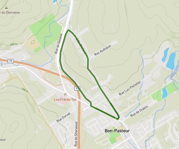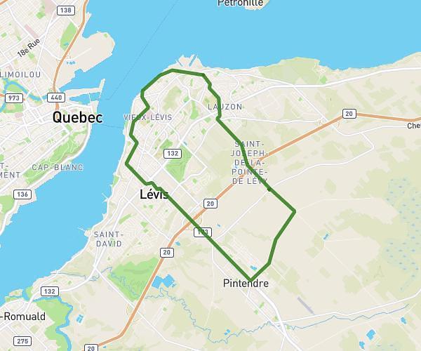
This hiking trail covers 12.634mi starting from Château-Richer, Quebec. The hike does not return to the trailhead and ends near Côte De La Fabrique, G1R 3V6 Québec. This hike is rated as easy, plan for about 12m to complete it. The route has an elevation gain of 581ft and an elevation loss of 446ft.
Description of the route by the creator
For more information about the Notre Dame de Quebec Trail, visit: <a rel="noopener noreferrer" target="_blank" href="https://www.kapoah.com">https://www.kapoah.com</a> Day 1: <a rel="noopener noreferrer" target="_blank" href="https://www.map-planner.fr/utilisateurs/kapoah/parcours/kapoah-1-10-la-malbaie-quebec-jour-1">https://www.map-planner.fr/utilisateurs/kapoah/parcours/kapoah-1-10-la-malbaie-quebec-jour-1</a> Day 2: <a rel="noopener noreferrer" target="_blank" href="https://www.map-planner.fr/utilisateurs/kapoah/parcours/kapoah-2-10-la-malbaie-quebec-jour-2">https://www.map-planner.fr/utilisateurs/kapoah/parcours/kapoah-2-10-la-malbaie-quebec-jour-2</a> Day 3: <a rel="noopener noreferrer" target="_blank" href="https://www.map-planner.fr/utilisateurs/kapoah/parcours/kapoah-3-10-la-malbaie-quebec-jour-3">https://www.map-planner.fr/utilisateurs/kapoah/parcours/kapoah-3-10-la-malbaie-quebec-jour-3</a> Day 4: <a rel="noopener noreferrer" target="_blank" href="https://www.map-planner.fr/utilisateurs/kapoah/parcours/kapoah-4-10-la-malbaie-quebec-jour-4">https://www.map-planner.fr/utilisateurs/kapoah/parcours/kapoah-4-10-la-malbaie-quebec-jour-4</a> Day 5: <a rel="noopener noreferrer" target="_blank" href="https://www.map-planner.fr/utilisateurs/kapoah/parcours/kapoah-5-10-la-malbaie-quebec-jour-5">https://www.map-planner.fr/utilisateurs/kapoah/parcours/kapoah-5-10-la-malbaie-quebec-jour-5</a> Day 6: <a rel="noopener noreferrer" target="_blank" href="https://www.map-planner.fr/utilisateurs/kapoah/parcours/kapoah-6-10-la-malbaie-quebec-jour-6">https://www.map-planner.fr/utilisateurs/kapoah/parcours/kapoah-6-10-la-malbaie-quebec-jour-6</a> Day 7: <a rel="noopener noreferrer" target="_blank" href="https://www.map-planner.fr/utilisateurs/kapoah/parcours/kapoah-7-10-la-malbaie-quebec-jour-7">https://www.map-planner.fr/utilisateurs/kapoah/parcours/kapoah-7-10-la-malbaie-quebec-jour-7</a> Day 8: <a rel="noopener noreferrer" target="_blank" href="https://www.map-planner.fr/utilisateurs/kapoah/parcours/kapoah-8-10-la-malbaie-quebec-jour-8">https://www.map-planner.fr/utilisateurs/kapoah/parcours/kapoah-8-10-la-malbaie-quebec-jour-8</a> Day 9: <a rel="noopener noreferrer" target="_blank" href="https://www.map-planner.fr/utilisateurs/kapoah/parcours/kapoah-9-10-la-malbaie-quebec-jour-9">https://www.map-planner.fr/utilisateurs/kapoah/parcours/kapoah-9-10-la-malbaie-quebec-jour-9</a> Day 10: <a rel="noopener noreferrer" target="_blank" href="https://www.map-planner.fr/utilisateurs/kapoah/parcours/kapoah-10-10-la-malbaie-quebec-jour-10">https://www.map-planner.fr/utilisateurs/kapoah/parcours/kapoah-10-10-la-malbaie-quebec-jour-10</a>