MapPlanner
1.198mi
Distance
29m22s
Duration
+502ft
Elevation gain
-499ft
Elevation loss
Moderate
Level

Malaussène d'en Haut et Bergerie des Deux Cyprès

Route details

2.45mph
Speed
233 kcal
Calories burned
15.8%
Avg grade
Loop trail
Route type
1289ft
Min altitude
1729ft
Max altitude
Steep climb

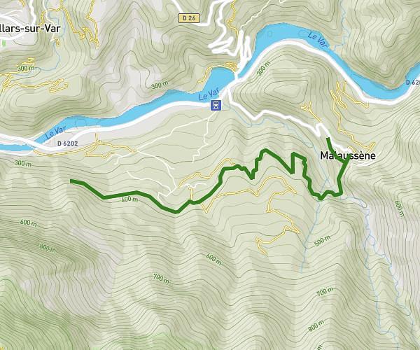
This hiking trail covers 1.198mi starting from Malaussène, Alpes-Maritimes. The hike is a loop trail and returns to the trailhead. This hike is rated as moderate, plan for about 29m22s to complete it. The route has an elevation gain of 502ft and an elevation loss of 499ft.

Description of the route by the creator

Discover the Deux Cyprès sheepfold and Saint-Joseph chapel along the Serse trail. ATTENTION: access to the path between beacons 6 and 7 is forbidden due to storm Alex (although the path is perfectly passable between beacon 6 and the sheepfold). If you still want to go, take the left-hand path at the marker and then the right-hand path at the second junction. On the way back, if you feel like it, you can make a short detour to the ruins of Malaussène d'en Haut.

(Description automatically translated)

Route profile

502ft
Elevation gain
499ft
Elevation loss
1289ft
Min altitude
1729ft
Max altitude

How to get there

Trailhead: 3 Place Du Centenaire, 06710 Malaussène, France

GPS coordinates of the trailhead: 43.927292, 7.130944 / 43°55'38'' N, 7°7'51'' E

Caution: May Cross Private Property

This route may pass through or near private property. Always respect posted signs, obtain permission where required, and follow local trespassing laws. MapPlanner does not guarantee public access along any route.

Safety Notice

Trail and road conditions may change without notice due to weather, construction, or other factors. Always verify current conditions before heading out. You are responsible for your own safety — follow local signage, obey traffic laws, and use your best judgment on the trail.