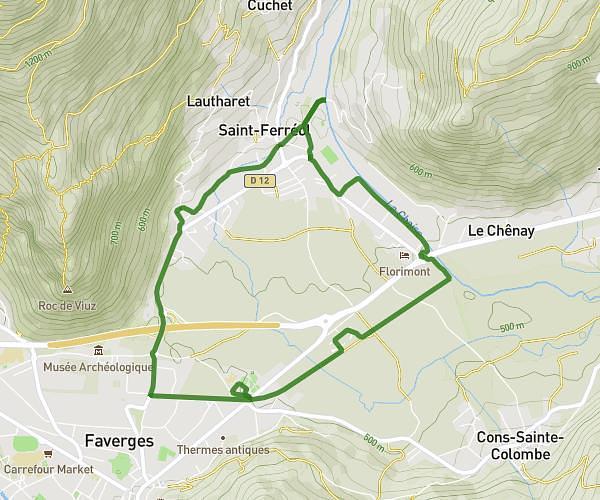
MapPlanner
  • Kilometers
  • Miles
  • France (€)
  • Belgique (€)
  • United Kingdom (£)
  • Ireland (€)
  • United States ($)
  • Canada ($CA)
  • Italia (€)
  • Deutschland (€)
  • Österreich (€)
  • España (€)
  • Schweiz (CHF)
  • Australia (AU$)
  • Calculate distance
    • Running
    • Hiking
    • Cycling
    • Walking
MapPlanner
  • Calculate distance
    • Running
    • Hiking
    • Cycling
    • Walking
  • Search a route

Create an Account

Log In

Faverges-Seythenex: Runs, Hikes and Bike Rides

  1. All Places
  2. France
  3. Haute-Savoie

Get inspired by these routes for your next outing

  • Running
  • Hiking
  • Bike
  • Walk
Calixte
Running

Calixte

4,331mi  •  1h  •  4,33mph
Haute-Savoie - Faverges-Seythenex
Pointe de la Sambuy depuis la station de la Sambuy
Hiking
Difficult

Pointe de la Sambuy depuis la station de la Sambuy

8,854mi  •  4h48m  •  +3829ft
Haute-Savoie - Faverges-Seythenex
Sommet de l'Arcalod
Hiking
Very difficult

Sommet de l'Arcalod

10,556mi  •  5h38m  •  +4698ft
Haute-Savoie - Faverges-Seythenex
La traversée de la Dent de Cons
Hiking
Very difficult

La traversée de la Dent de Cons

12,353mi  •  10h51m  •  +5594ft
Haute-Savoie - Faverges-Seythenex
No rides for this type yet
Your country
France (km)
Belgique (km)
United Kingdom (km)
Ireland (km)
United States (mi)
Canada (km)
Italia (km)
Deutschland (km)
Österreich (km)
España (km)
Schweiz (km)
Australia (km)
MapPlanner
Subscription
Blogs
Contact us
About
Terms of use
Privacy policy
Sales terms
Plan your routes
Running / Jogging
Hiking / Trail
Cycling / MTB
Walks / Strolls
Popular routes by location
Discover all locations
California - United States
Ladera Ranch
Los Angeles
Petaluma
Redding
San Diego
Sonoma
Visalia
© Copyright 2025 (3.6.68). All rights reserved. Powered by SeoCache and the best blog platform: GinkoNote.
Success
Success
Success
Success