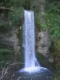
This hiking trail covers 0.519mi starting from Corbonod, Ain. The hike does not return to the trailhead and ends near Chemin De La Cascade, 01420 Corbonod. This hike is rated as easy, plan for about 16m42s to complete it. The route has an elevation gain of 36ft and an elevation loss of 118ft.
Cascade d'Eilloux
Route details
1.86mph
Speed
119 kcal
Calories burned
5.6%
Avg grade
Point to point
Route type
1050ft
Min altitude
1148ft
Max altitude
Route profile
36ft
Elevation gain
118ft
Elevation loss
1050ft
Min altitude
1148ft
Max altitude
How to get there
Trailhead: Chemin De Charveyron, 01420 Corbonod
GPS coordinates of the trailhead: 45.97025, 5.82119 / 45°58'12'' N, 5°49'16'' E


