This hiking trail covers 1.09mi starting from Matafelon-Granges, Ain. The hike does not return to the trailhead and ends near 36 Impasse Des Prairies, 01580 Matafelon-Granges, France. This hike is rated as easy, plan for about 35m4s to complete it. The route has an elevation gain of 187ft and an elevation loss of 315ft.
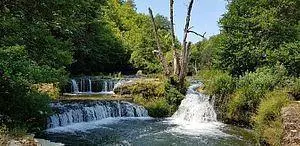
Cascades de l'Oignin
Route details
1.86mph
Speed
259 kcal
Calories burned
8.7%
Avg grade
Point to point
Route type
1073ft
Min altitude
1253ft
Max altitude
Steep climb
Route profile
187ft
Elevation gain
315ft
Elevation loss
1073ft
Min altitude
1253ft
Max altitude
How to get there
Trailhead: 520 Rue De Charmine, 01580 Matafelon-Granges, France
GPS coordinates of the trailhead: 46.266, 5.57183 / 46°15'57'' N, 5°34'18'' E