MapPlanner
16.923mi
Distance
5h27m
Duration
+6404ft
Elevation gain
-6549ft
Elevation loss
Strenuous
Level

Boucle Vallée du Lutour / vallée de Gaube

Route details

3.11mph
Speed
2562 kcal
Calories burned
14.5%
Avg grade
Loop trail
Route type
3461ft
Min altitude
8507ft
Max altitude
High altitude Steep climb

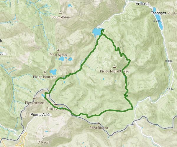
This hiking trail covers 16.923mi starting from Cauterets, Hautes-Pyrénées. The hike is a loop trail and returns to the trailhead. This hike is rated as strenuous, plan for about 5h27m to complete it. The route has an elevation gain of 6404ft and an elevation loss of 6549ft.

Description of the route by the creator

Departure from La Raillère Take the Lutour valley to Lac d'Estom Pass into the Gaube valley via the col de l'arraillé Descend to the Oulettes refuge for a bivouac (15km, 1700d+ and 650d-) Descend to La Raillère via Lac de Gaube and Pont d'Espagne

(Description automatically translated)

Route profile

6404ft
Elevation gain
6549ft
Elevation loss
3461ft
Min altitude
8507ft
Max altitude

How to get there

Trailhead: Route Du Pont D'espagne, 65110 Cauterets, France

GPS coordinates of the trailhead: 42.871344, -0.109119 / 42°52'16'' N, 0°6'32'' W

Caution: May Cross Private Property

This route may pass through or near private property. Always respect posted signs, obtain permission where required, and follow local trespassing laws. MapPlanner does not guarantee public access along any route.

Safety Notice

Trail and road conditions may change without notice due to weather, construction, or other factors. Always verify current conditions before heading out. You are responsible for your own safety — follow local signage, obey traffic laws, and use your best judgment on the trail.