MapPlanner
2.456mi
Distance
1h13m
Duration
+1132ft
Elevation gain
-125ft
Elevation loss
Moderate
Level

De Chemin Forestier de la Goutte à Les Luzes

Route details

2.01mph
Speed
589 kcal
Calories burned
9.7%
Avg grade
Point to point
Route type
2940ft
Min altitude
4072ft
Max altitude
Technicity: Technical Steep climb

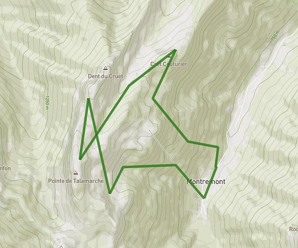
This hiking trail covers 2.456mi starting from Annecy, Haute-Savoie. The hike does not return to the trailhead and ends near Chemin Forestier De La Goutte, 74000 Annecy, France. This hike is rated as moderate, plan for about 1h13m to complete it. The route has an elevation gain of 1132ft and an elevation loss of 125ft.

Route profile

1132ft
Elevation gain
125ft
Elevation loss
2940ft
Min altitude
4072ft
Max altitude

How to get there

Trailhead: Chemin Forestier De La Goutte, 74000 Annecy, France

GPS coordinates of the trailhead: 45.85132, 6.1093 / 45°51'4'' N, 6°6'33'' E
Download / Export

GPX

Hiking trails nearby

Sortie du 2026-08-14
Flo+explorer
Hiking
Easy

Sortie du 2026-08-14

2.528mi
28m
+62ft
Haute-Savoie - Annecy
Dent du Cruet depuis Montremont
Flo
Hiking
Strenuous

Dent du Cruet depuis Montremont

8.351mi
5h
+4587ft
Haute-Savoie - Thônes
Sortie du 2026-08-11 - 1
Flo+explorer
Hiking
Easy

Sortie du 2026-08-11 - 1

1.012mi
5m8s
+410ft
Haute-Savoie - Annecy
De Quai Eustache Chappuis à Route du Semnoz
Flo+explorer
Hiking
Moderate

De Quai Eustache Chappuis à Route du Semnoz

1.182mi
13m
+367ft
Haute-Savoie - Annecy

Recommended routes for you

Pointe de Talamarche depuis Montremont
Flo
Hiking
Hard

Pointe de Talamarche depuis Montremont

7.289mi
4h15m
+4035ft
Haute-Savoie - Thônes
Col de la Buffaz
Flo
Hiking
Moderate

Col de la Buffaz

4.092mi
3h25m
+1991ft
Haute-Savoie - Thônes
Le Môle depuis Ayse
Flo
Hiking
Moderate

Le Môle depuis Ayse

8.039mi
4h1m
+3524ft
Haute-Savoie - Ayse
Cascades d'Angon
Flo
Hiking
Easy

Cascades d'Angon

3.204mi
3h15m
+1093ft
Haute-Savoie - Talloires-Montmin

Caution: May Cross Private Property

This route may pass through or near private property. Always respect posted signs, obtain permission where required, and follow local trespassing laws. MapPlanner does not guarantee public access along any route.

Safety Notice

Trail and road conditions may change without notice due to weather, construction, or other factors. Always verify current conditions before heading out. You are responsible for your own safety — follow local signage, obey traffic laws, and use your best judgment on the trail.