This hiking trail covers 1.68mi starting from Saint-Germain-les-Paroisses, Ain. The hike does not return to the trailhead and ends near Parcours Sportif, 01300 Saint-Germain-les-Paroisses. This hike is rated as moderate, plan for about 54m3s to complete it. The route has an elevation gain of 1352ft and an elevation loss of 82ft.
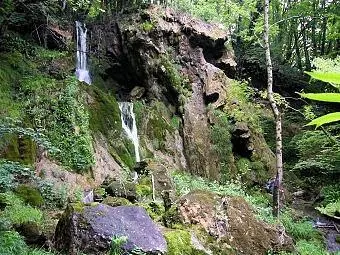
Cascade de la côte droite
Route details
1.86mph
Speed
474 kcal
Calories burned
16.2%
Avg grade
Point to point
Route type
1227ft
Min altitude
2566ft
Max altitude
Steep climb
Route profile
1352ft
Elevation gain
82ft
Elevation loss
1227ft
Min altitude
2566ft
Max altitude
How to get there
Trailhead: Rue De L'école, 01300 Saint-Germain-les-Paroisses
GPS coordinates of the trailhead: 45.77373, 5.61896 / 45°46'25'' N, 5°37'8'' E