This hiking trail covers 0.848mi starting from Foncine-le-Bas, Jura. The hike does not return to the trailhead and ends near Tram'jurassienne, 39520 Foncine-le-Bas, France. This hike is rated as easy, plan for about 27m18s to complete it. The route has an elevation gain of 299ft and an elevation loss of 121ft.
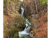
Cascade du bief de la ruine
Route details
1.86mph
Speed
212 kcal
Calories burned
9.4%
Avg grade
Point to point
Route type
2589ft
Min altitude
2792ft
Max altitude
Steep climb
Route profile
299ft
Elevation gain
121ft
Elevation loss
2589ft
Min altitude
2792ft
Max altitude
How to get there
Trailhead: 39 Chemin Des Douanets, 39520 Foncine-le-Bas, France
GPS coordinates of the trailhead: 46.63896, 6.03016 / 46°38'20'' N, 6°1'48'' E