Saturday evening, the pack is by the door. Before turning in, you open your route one last time: the hiking weather forecast for the trailhead, tomorrow's sunset, the nearest parking lot and the drive from home. It all sits right under the map.
These four tools live in the Prepare my outing section below your route, both in the planner and on a saved route's page. They all work from the first point of your route, so as soon as a start is on the map, you can get ready.
A hiking forecast for the exact start point
The forecast is not for the nearest town but for the coordinates of your start. In the mountains that matters: a valley village and a parking lot at the top of a pass don't always share the same sky. Times are shown in the local time of the place, so there is no mix-up when you plan a trip abroad, even across time zones.
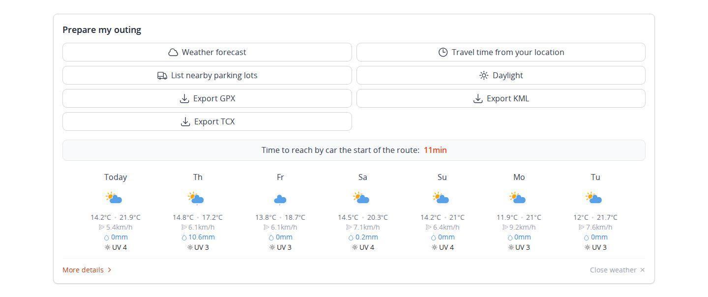
The overview covers the coming week, starting today. For each day you get:
- the sky, as an icon (sun, cloud, fog, drizzle, rain, showers, snow, thunderstorm);
- the minimum and maximum temperatures;
- the top wind speed;
- total precipitation, in millimeters;
- the day's highest UV index.
If you use miles, temperatures switch to Fahrenheit, wind to mph and rain to inches.
Plan your own route
MapPlanner helps you calculate distances, elevation, duration and plan your hikes, runs and bike rides on an interactive map.
- Automatic distance & elevation calculation
- Topographic, satellite maps
- GPX/KML export for your GPS
- Real-time GPS tracking
Morning, afternoon or evening: pick your window
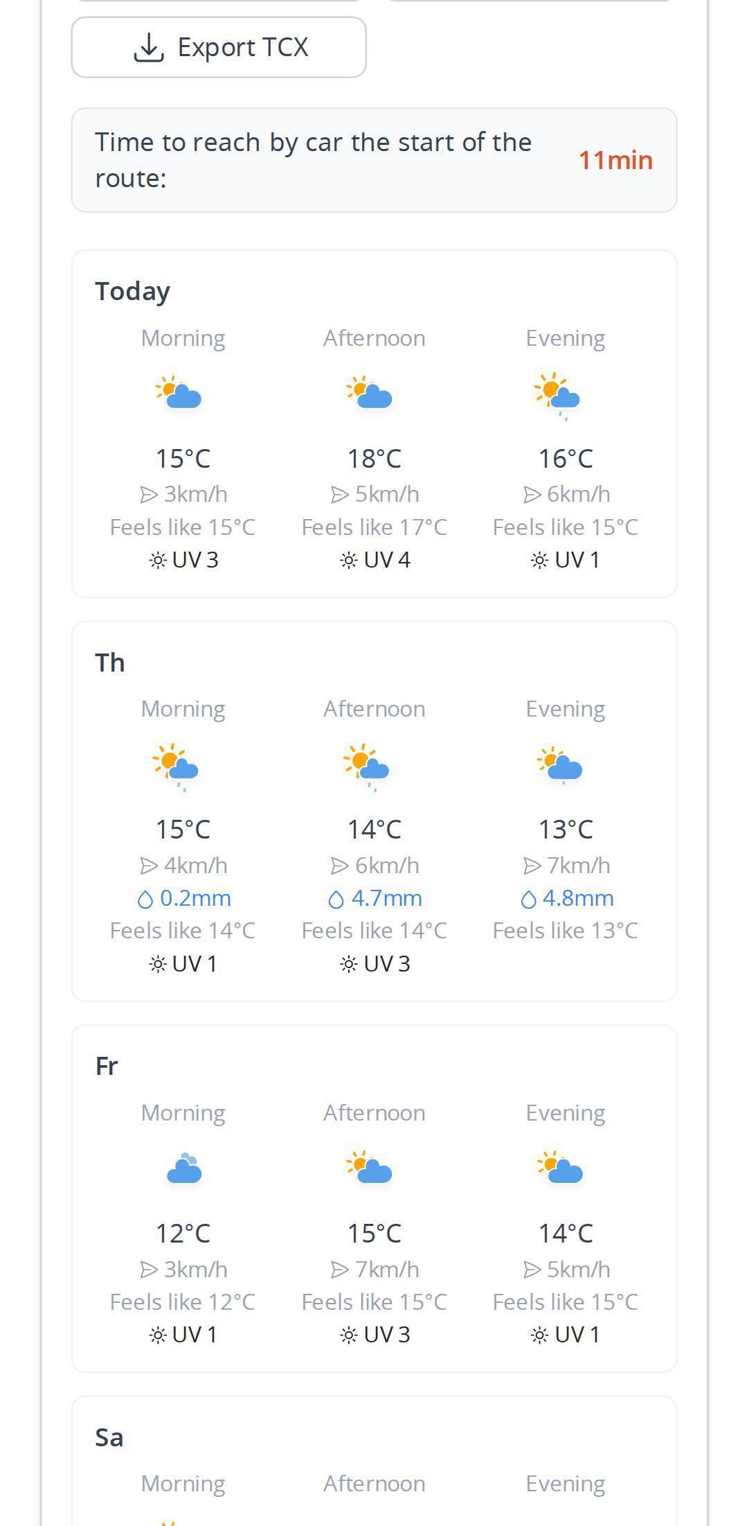
Knowing it will rain on Tuesday does not tell you when. More details splits each day into three windows: morning, afternoon and evening. For each one you see the average temperature and how it feels, the strongest wind, any rain expected and the peak UV index.
Each window's icon shows the worst weather expected in those hours, not an average. A single stormy hour in a sunny afternoon still shows up, which is exactly what you need to know to decide between a dawn start and moving the hike to another day.
Daylight: know when the light runs out
Daylight lists, for the next seven days at the start point, civil dawn, sunrise, solar noon, sunset, civil dusk, day length and usable light. A one-line summary gives the window for the week: from what time to what time you can walk with enough natural light.
Civil dawn and dusk are the moments when the sun is less than 6° below the horizon: there is still enough light to walk without a headlamp. In fall and winter, the light often decides how long the outing can be, well before your legs do.
Find parking near the trailhead
Circling for twenty minutes looking for a space is a poor start to the day. List nearby parking lots searches for parking around your start in the map data, which comes from OpenStreetMap. If the map is zoomed too far out, it first moves in on the start, then highlights the parking lots on the map.
A selection of the closest ones appears as a list, nearest first. For each you see:
- its name, when it has one;
- the distance to the start, in meters;
- in most cases, the walking time, worked out along paths rather than as the crow flies.
Tap a parking lot and the map zooms right in on it: you can spot the entrance, the access road and the path to the start. Tap the button again to close the list and clear the highlight.
Driving time to the start, from home or anywhere else
Travel time from your location opens its own window. Tell it where you are setting off from:
- type an address or a place name;
- use your current location;
- or pick one of your recent addresses: home, the vacation rental, the campground.
A map then shows your departure point, the start of the route and the road between them. Drag your point on the map and the time updates straight away. The result is a driving time along the fastest route. It stays on display in the Prepare my outing section afterwards.
It is calculated without traffic, as a best-case time: allow extra at rush hour or on busy weekends near popular spots. It helps you set the alarm or choose between two routes when one is an hour further away.
On a saved route's page
Once your route is saved, its page offers the same tools plus a How to get there block: the start address and its GPS coordinates, in decimal degrees and in degrees, minutes and seconds. On a phone, a button opens your navigation app straight on the start point. Parking lots near the start (and near the finish for a one-way route) are also listed in the printable roadbook.
Tips for heading out at the right time
- Check the forecast twice: a few days ahead to pick the date, then the evening before to pick the time. The closer the day, the more reliable the forecast.
- In the mountains, think about the summit. The forecast is for the start; higher up it is usually colder and windier. The feels-like temperature and the wind for your window tell you which layer to pack.
- Thunderstorm in the afternoon? Start early and aim to be back by noon. The estimated hiking time tells you when to set off.
- Keep an eye on the UV index in summer and on snow: at altitude it climbs fast, even on a cool day.
- Plan to finish before civil dusk with breaks included. Late in the season, carry a headlamp.
- Note a second parking lot from the list: on a sunny weekend the first one is often full.
Free and mostly without an account
Weather, daylight and the parking list are free and work without an account. Travel time is free too: visitors get a limited number of calculations over a limited distance to the start. A free account gives a little more room. The Explorer plan makes it unlimited, from much further away.
Weekend coming up? Draw your hike in the planner, then scroll below the map: the trailhead forecast is waiting.
Weather, parking and access: your questions
How many days ahead does the forecast go?
The coming week, starting today, day by day. The morning, afternoon and evening breakdown is available for each of those days.
Is the weather forecast for the exact start of the hike?
Yes. It is calculated for the coordinates of the first point of your route, not for the nearest town. Times are shown in the local time of the place.
How do I find parking for a hike?
Place your start, then ask for the list of nearby parking lots under the map. You get the parking lots around the start, with their distance and the walking time to the beginning of the route.
Does the driving time include traffic?
The time shown is the best-case driving time, calculated without traffic. Leave some margin at rush hour and on busy weekends near popular spots.
Do I need an account to check the weather?
No. Weather, daylight and parking work without an account. Only travel time is limited without a subscription; it is unlimited with the Explorer plan.


