Your distance, your total climbing and your best outings, worked out for you on a single page: the MapPlanner activity log sums up every sport you do, with no spreadsheet and no math.
How many miles this year? What was your biggest day of climbing? The My activities page answers at a glance. It brings together every route you have completed, activity by activity, with totals, averages and records. Runners follow their volume, trail runners their elevation gain, hikers their best days and cyclists their mileage.
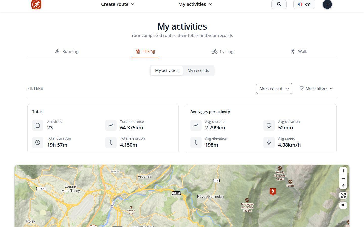
Totals and averages for each activity
Once signed in, open the My activities menu and pick your completed routes. Tabs separate running, hiking, cycling and walking. The page opens straight on the default activity set in your profile.
At the top, two blocks sum up the selected activity:
- totals: number of outings, total distance, total duration and total elevation gain;
- averages per outing: distance, duration, elevation gain and speed.
Below them, the list of your completed outings lets you reopen any of them. The page is private: only you can see it.
Plan your own route
MapPlanner helps you calculate distances, elevation, duration and plan your hikes, runs and bike rides on an interactive map.
- Automatic distance & elevation calculation
- Topographic, satellite maps
- GPX/KML export for your GPS
- Real-time GPS tracking
Your records, top three in each category
Switch to My records to see your three best outings in each category, with their date:
- longest distance;
- longest duration;
- biggest climb;
- fastest average, as a pace for running and walking, as a speed for hiking and cycling;
- highest altitude reached.
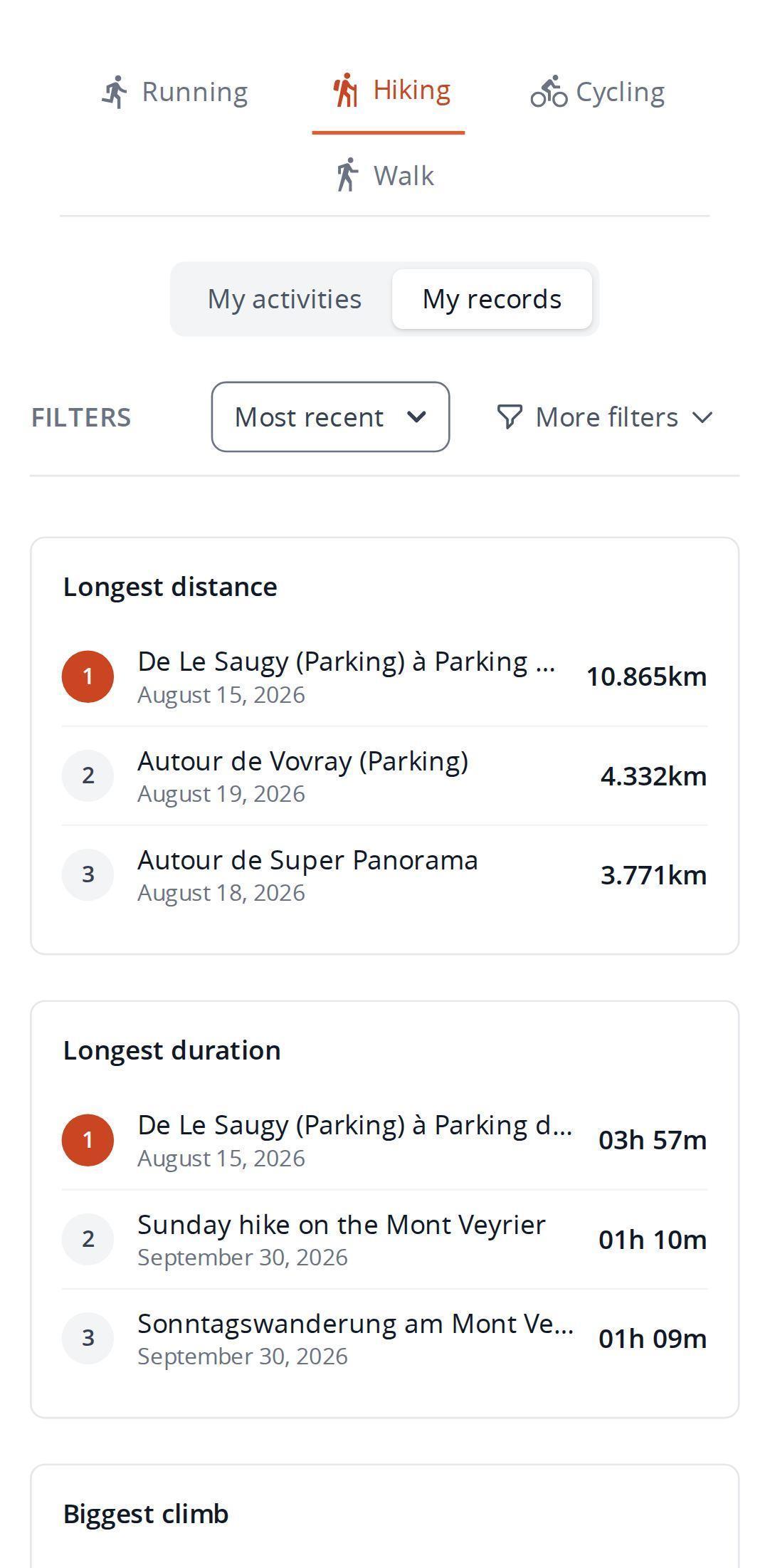
A podium is a good motivator: beating your third-longest outing is often more within reach than the all-time record. And just as satisfying.
Filter your history to compare periods
Filters sort the list by completion date, distance or duration. Further criteria let you narrow it down to:
- a difficulty level;
- a route type, loop or one-way;
- a range of distance and elevation gain;
- a period: the last seven or thirty days, a given year or custom dates.
Totals, averages and records update straight away to match. That is where the log becomes a real tracking tool: compare one month with the last, one season with another or your usual loops with each other.
The right filter for your sport
Running? The last thirty days show your current volume; custom dates covering the previous month give you something to measure it against. On the trails, keep only the outings with plenty of elevation gain: your mountain days stand on their own and their average speeds finally compare like for like. For hiking, a single year is enough to review the season, with total distance and climbing. On the bike, keeping only loops shows how your usual rides are coming along.
How an outing gets into your log
Only completed routes count toward totals and records. You add them in two ways: import the track from your watch or GPS device with Import a GPX or mark a route you had planned as completed. The guide to tracking your performance covers both. Every completed outing also tunes the estimated times of your next routes to your own pace.
The same menu leads to your other lists: planned, shared, collaborative and favorite routes. Your routes land there as soon as you save a route. Planned routes are shown as a list without totals or records, since you have not done them yet.
Tips for a log that means something
- Pick the right activity when you save: a run filed under hiking skews the averages of both tabs.
- Check the completion date, especially when importing old tracks: it puts the outing in the right period.
- Set your default activity in your profile to land straight on the one you do most.
Included in the free account
The My activities page with its totals, averages, records and filters comes with the free account. That account lets you save and import a limited number of routes; the Explorer plan lifts those limits so your whole history fits.
Every log starts with a first outing. Plan the next one in the route planner and watch your totals climb season after season.
Activity log: your questions
Where can I see my total distance on MapPlanner?
In the My activities menu, on your activity's tab: the totals show the combined distance, duration and elevation gain of your completed routes, recalculated for the filters you choose.
Can other people see my activity log?
No. Your activities page is visible to you only.
Why is an outing missing from my records?
Records only include completed routes. A route that is still planned needs to be marked as completed first.
Can I compare two periods?
Yes. The period filter accepts a year or custom dates: apply it one after the other to compare totals and averages.


