Planning a route as a group over messages means forty notifications, three screenshots of three different maps and nobody sure which version won. The MapPlanner collaborative route puts the whole group on one map: everyone proposes a route, compares, then votes.
Route, date, meeting point and chat all live on one page. Hiking clubs save time with it. So do trail running groups and cycling friends.
Set up a group outing in minutes
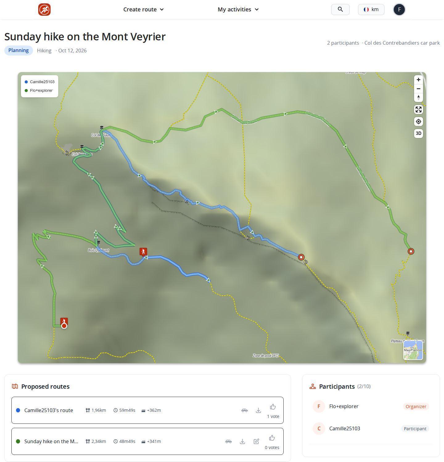
You start a collaborative outing from the site menu. Draw a first proposal on the map, just as in the route planner, then describe the outing: name, activity, level, maximum number of participants, planned date and meeting point. The group page is created with your route as the organizer's route.
Then invite the group. Search for a member by username or type an email address: that person gets an invitation even without a MapPlanner account yet.
Plan your own route
MapPlanner helps you calculate distances, elevation, duration and plan your hikes, runs and bike rides on an interactive map.
- Automatic distance & elevation calculation
- Topographic, satellite maps
- GPX/KML export for your GPS
- Real-time GPS tracking
Compare routes side by side on one map
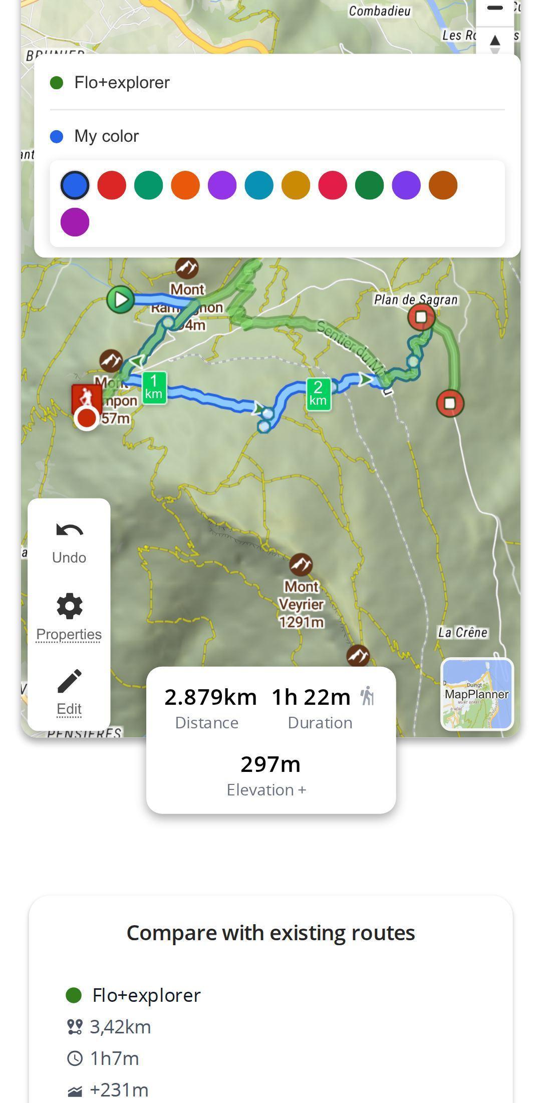
Once in the group, everyone picks a role. Happy with the organizer's route? Accept it, which counts as a vote. Think there is a better way? Draw your own variant.
Each proposal appears in the color its author picked; a legend shows who drew what. While you draw, a table sets your variant against the existing routes: distance, duration, elevation gain and level, side by side. No more "is yours longer?".
Vote on the route and the date
Each participant votes with one click for one or more routes; the vote count shows under each route. Dates work the same way: everyone suggests when they are free, then votes for the dates that suit them. The group watches a decision take shape instead of digging for it in the chat.
The page updates in real time. When someone proposes a route, votes, comments or adds a photo, the others see it without reloading. The discussion handles logistics, the photo album keeps the memories. A group wishlist collects ideas for future outings, picked from your favorites.
On the day: GPX export and travel time to the start
Every proposed route can be exported as GPX for your watch or GPS unit. An estimate of the driving time from your position to the start also helps the group pick a starting point that works for everyone.
A collaborative route for every kind of group
- Hiking club: the organizer proposes a loop and a member suggests a shorter variant for beginners. The table shows the difference in elevation gain; the vote decides.
- Trail running group: everyone draws their version of Sunday's long run, then the group compares distance and elevation gain.
- Cycling friends: several loops side by side, with the driving time settling which start suits most people.
- Walking association: proposed dates save the back-and-forth of finding a day that works.
Tips for an outing that gets decided fast
- Give a precise meeting point and a realistic level: they are the first things participants read.
- Suggest a date straight away. If it does not suit, others will propose alternatives.
- Invite friends without an account by email rather than waiting for them to sign up.
- To simply send a route without a vote, sharing by link is enough. When you head out alone, planning your future outings keeps your ideas on a personal map.
Collaborative routes: free account and Explorer plan
You can draw on the page without an account. To save the outing and invite friends, a free account is enough: it allows a few collaborative outings with a limited number of invitations. The Explorer plan makes outings and invitations unlimited. Guests only need a free account to join the group, propose a route and vote.
Your next outing can be settled without forty messages: start your collaborative route, invite the group and let the map decide.
Planning a group outing: your questions
Are collaborative routes free?
Yes. A free account lets you create a few collaborative outings and invite participants. The Explorer plan lifts the limits on outings and invitations.
Do my friends need a MapPlanner account?
To join the group, propose a route, vote or comment, yes: a free account is enough. If someone has not signed up yet, invite them with their email address.
Which activities can I organize a group outing for?
All the activities of the planner: running, hiking, cycling and walking. You pick the activity when you create the outing.
Can I load the chosen route onto my watch or GPS?
Yes. Every route proposed in the group can be exported as GPX, ready for a watch, a GPS unit or another app.


