How many outings have you spotted and never actually done? To plan your hikes, trail runs and rides, MapPlanner gives you a map of places to try: every idea becomes a dated marker, ready for a route.
A summit from a magazine, a lake a friend mentioned, a loop you want to test before summer. Instead of fading in a notebook, these ideas land on the map with a name, an activity, your notes and a time frame. When the day gets closer, you draw the route from the place itself and already know how long it will take.
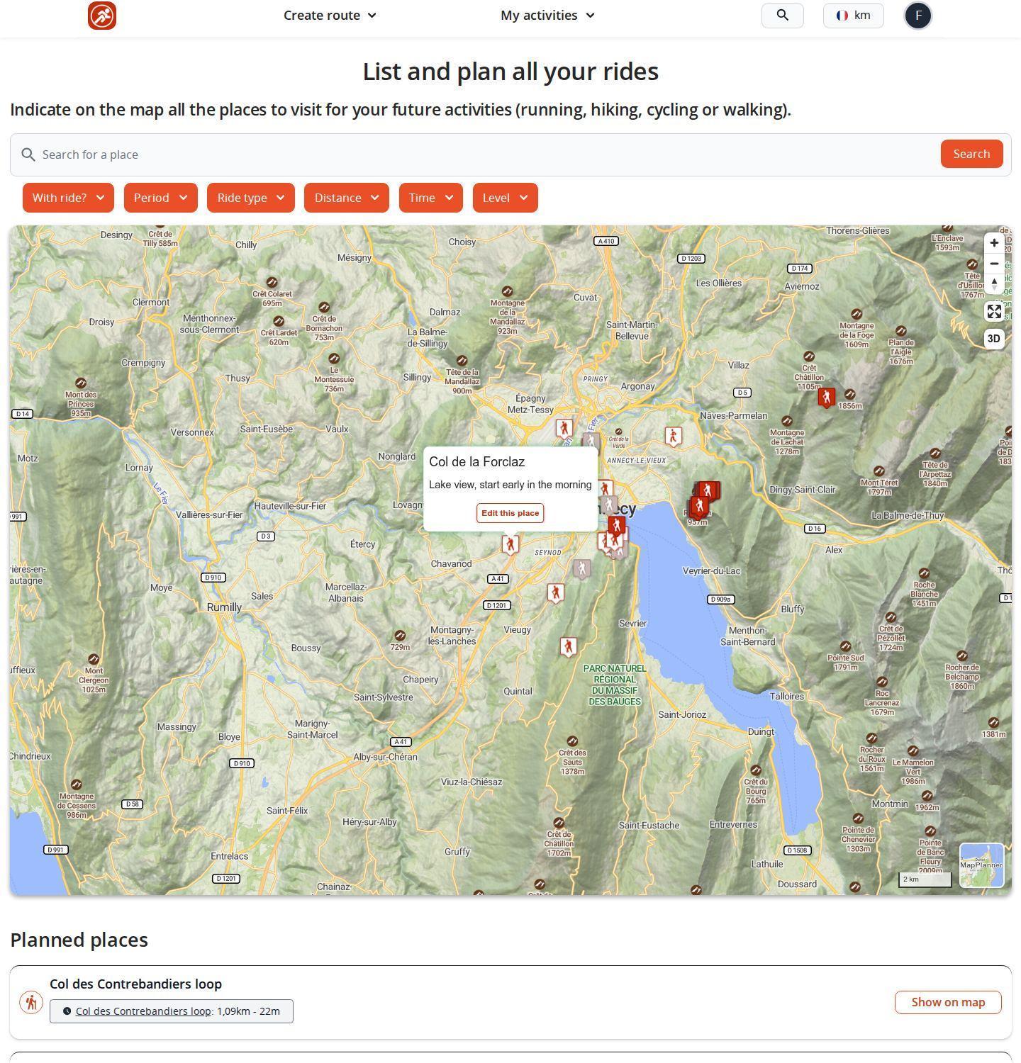
Turn an outing idea into a marker on the map
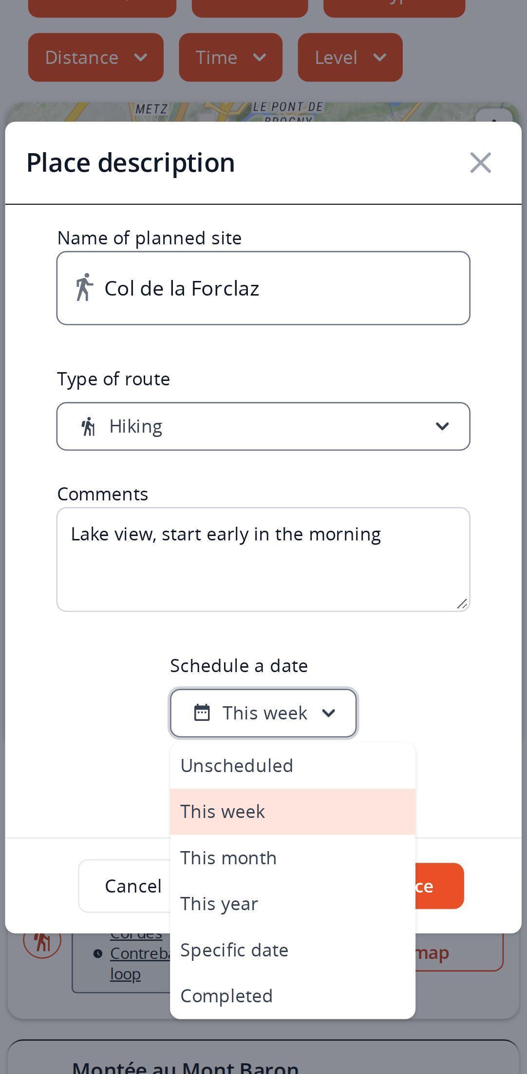
The planning page opens from the My activities menu, under Places to try. Search for the area you have in mind, then click the map (or tap it on a phone) where you want to go: a window opens to describe the place.
Give it a name, pick the activity (running, hiking, cycling or walking) and add a note if useful: access, best season, gear to pack. Then say when: this week, this month, this year or a specific day picked from a calendar. A plain wish can stay undated. The marker shows up right away on the map and in the list underneath.
Plan your own route
MapPlanner helps you calculate distances, elevation, duration and plan your hikes, runs and bike rides on an interactive map.
- Automatic distance & elevation calculation
- Topographic, satellite maps
- GPX/KML export for your GPS
- Real-time GPS tracking
Draw the route for a planned place ahead of time
From the place window you can draw the route starting at the marker. MapPlanner shows the estimated time and you set the level, so weighing up two summits you are eyeing for the same month takes seconds.
That route is saved as a planned route with private visibility: only you can see it. It also appears in the same menu, under Planned routes. A route drawn straight in the planner can take the same path: just mark it as planned when you save the route.
Filter planned outings by the time you have
A few weeks in, the map fills up. The filters above it keep things readable: period, activity, level, distance, duration and whether a route is attached. Got three hours on Saturday morning? Filter by duration and the map only shows what fits.
The list below the map repeats each place with its activity, your description and any attached route with its distance, duration and level. One button recenters the map on the place you pick. Trail runners keep their training spots here, cyclists the climbs they want to tick off, hikers the summits of the season and families their easy Sunday walks.
For routes by other people that you find online, favorites and collections are the natural companion to this map.
After the outing, keep track of what you have done
A finished outing does not vanish: reopen the place, mark it as done and enter the date. If a route was attached, the window offers to complete it with what really happened. Season after season, the map turns into a record of everything you have ticked off.
Tips for a planning map you will actually use
- Write down what people forget in the note: where to park, the water point, the section to avoid when it rains.
- Don't date everything. Keep loose ideas undated and save time frames for outings you have decided on, so the period filter stays meaningful.
- Draw routes for this month's outings rather than for every idea: that is where comparing estimated durations helps you choose.
- A misplaced marker can be moved by drag and drop, after a confirmation. On a computer, right-click a marker to delete it.
Free with an account, no ceiling with the Explorer plan
Saving a place needs a free account: if you are not signed in, MapPlanner offers to create one when you confirm. A free account allows a limited number of planned places and planned routes up to a capped duration, breaks included. Recorded or imported outings are never affected by that cap.
The Explorer plan lifts these limits: unlimited planned places and planned routes over several days, nights included, to prepare a hut-to-hut trek or a bivouac trip.
The next outing idea that crosses your mind deserves better than a lost note. Open your map of places to try and drop your first marker.
Planning your outings: common questions
Is hike planning free on MapPlanner?
Yes, with a free account: you can plan a limited number of places and routes up to a capped duration. The Explorer plan makes places unlimited and allows planned routes over several days.
Can I plan outings from my phone?
Yes. The page works in your smartphone browser: tap the map to add a place and the same description window opens.
Who can see my planned routes?
Only you. A route drawn from a planned place is saved with private visibility.
How do I find a planned outing that fits into half a day?
Use the duration filter above the map: only places whose attached route matches stay visible. You can combine it with the activity, level and distance filters.


