A single-color line on a map tells you neither where the climbing gets steep nor where the pavement turns to gravel. By coloring your route by gradient or by surface, MapPlanner puts both answers right on the map before you head out. And for your own landmarks, you can paint each leg in a color of your choice.
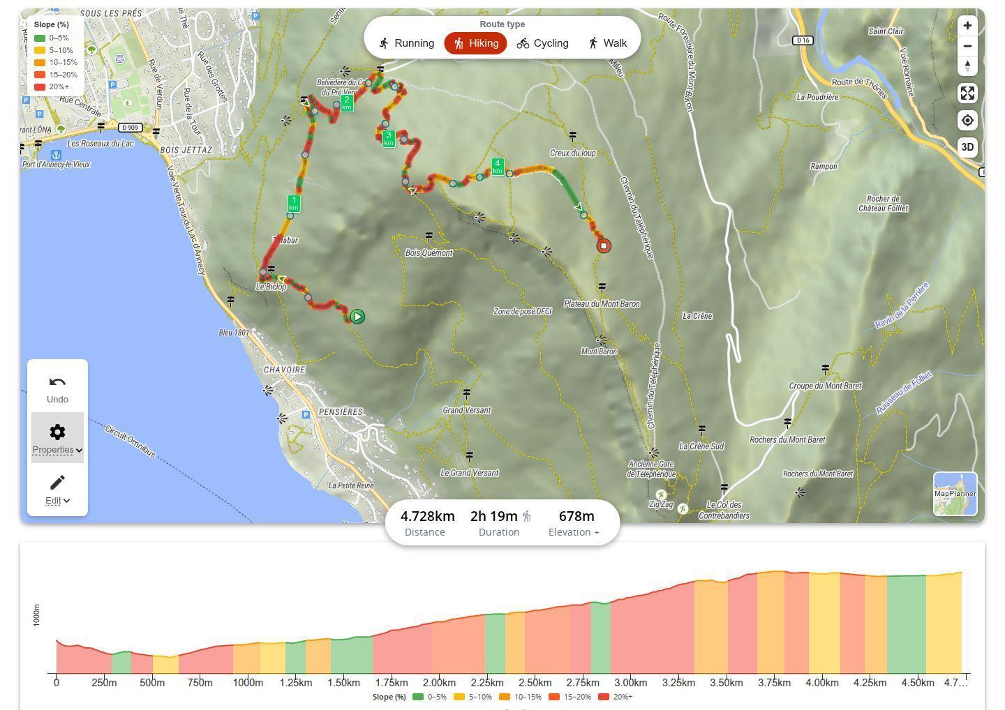
Spot the steep climbs with gradient colors
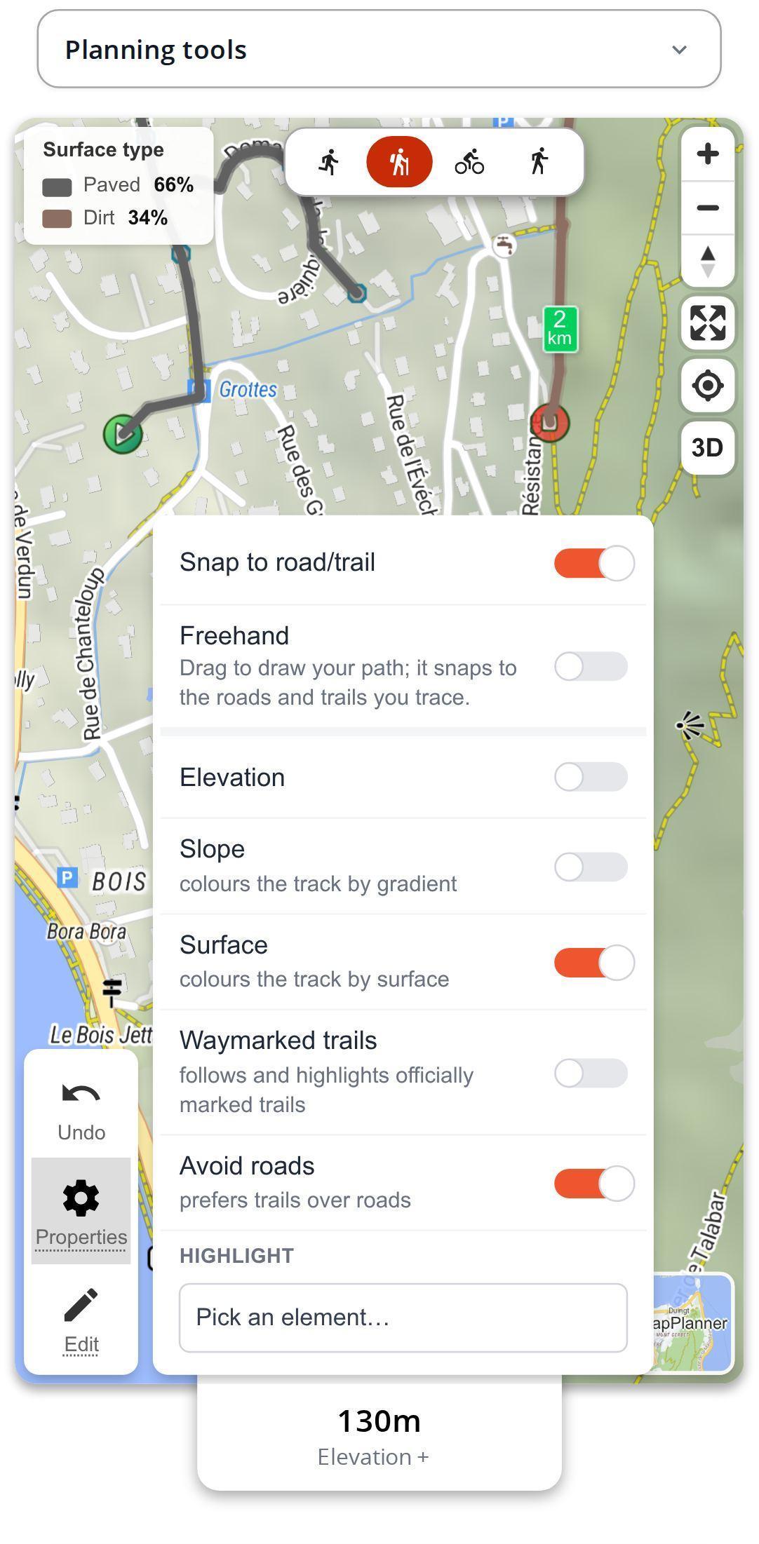
In the map's Properties menu, switch on Slope. Each part of the route takes the color of its gradient and a legend appears on the map:
- green from 0 to 5%;
- yellow from 5 to 10%;
- orange from 10 to 15%;
- deep orange from 15 to 20%;
- red above 20%.
The color works uphill and downhill alike: a red leg is steep in both directions, whether you are grinding up it or picking your way down. The coloring becomes available as soon as the route's elevation profile has been calculated.
Plan your own route
MapPlanner helps you calculate distances, elevation, duration and plan your hikes, runs and bike rides on an interactive map.
- Automatic distance & elevation calculation
- Topographic, satellite maps
- GPX/KML export for your GPS
- Real-time GPS tracking
See where the surface changes
Switch on Surface instead and the route takes the color of the ground underfoot: paved, compacted, gravel, dirt, grass or wood. Stretches with no information are marked as unknown. Only one coloring shows at a time, so turning one on turns the other off.
For cyclists this is often the deciding factor. An all-paved route calls for the road bike, while a loop mixing gravel and dirt points to the gravel bike or the MTB. The PDF roadbook also includes the breakdown of surfaces as percentages.
An elevation profile in the same colors
Turn on Elevation in the same menu and the profile appears below the map in the gradient colors. You see at a glance where the ramps are bunched together and how long each one lasts. Hover over the profile to read the gradient at that point as a percentage, smoothed over a short distance so it does not jump at every pebble. The elevation profile has its own guide if you want to dig deeper.
Pick your own colors, leg by leg
Automatic colors do not tell the whole story. In the Edit menu, the section color tool lets you tap a leg and give it a shade from the palette or return it to its original color. A leg runs from one point you placed to the next.
That way you can tell the way out from the way back on an out-and-back, mark the stretch a group rides together before splitting up or flag the parts to rework before sharing the route. These colors are saved with the route and shown on its page.
Reading the colors for your activity
On a hike, the orange and red legs are the ones to check before setting off with children or a mixed group: plan your breaks at their foot and compare them with the route's estimated difficulty level. For trail running, green marks the runnable stretches and red the walls you will power-hike, along with the descents that hammer your quads. Out for a walk with a stroller? The surface coloring shows you where the pavement and compacted paths are.
Our tips for a readable route
- Place a point where you want a section color to start: the leg begins exactly there.
- A long stretch of unknown surface? Switch to satellite view to get a feel for the ground.
- A short red section does not weigh the same as a long orange climb, so always read the map together with the elevation profile.
- Before settling on a loop, switch on the gradient colors: moving a single point is sometimes enough to dodge a nasty ramp.
On the route page, for you and the people you share with
Once the route is saved, the gradient and surface toggles stay available on the map of its page. The people you share the route with see the same colors as you, with nothing to install.
Gradient and surface coloring, section colors and the colored profile are free in the planner, even without an account. A free account simply lets you save the route so its colors show on its page.
Your next route may be hiding a wall. Draw it in the planner, switch on the gradient and you will know exactly where it is.
Route colors: your questions
Is coloring the route by gradient free?
Yes. Gradient, surface and section colors are open to everyone in the planner, with no subscription.
How accurate are the gradient colors?
The gradient is calculated from the elevation profile, smoothed over a short distance, then placed in one of the five bands. It is a reliable reading of climbs and descents, built for planning an outing rather than measuring every meter.
What does an unknown surface mean?
The surface is not recorded for every path. On those stretches, satellite view helps you picture the ground.
Does it work on a phone?
Yes. The colorings, legends and section colors work in your smartphone's browser just as they do on a computer.


